| |
|
|
Whilst there are plenty of us with a GPS unit we rarely use even a limited percentage of its capability. Many of us are unsure how to link what we see on the screen to the charts we have or we are unsure what XTE stands for and whether what it says matters anyway. Certainly, when I first used a GPS XTE, BTW and TTG meant nothing to me. Over the next page or two we’ll look at what a GPS can do and what the various abbreviations mean. So what is a GPS?
GPS (or ‘Global Positioning System’) was created by the US Government for military use. A GPS receiver computes its position relative to a number of satellites orbiting the earth and represents
its position on the earth’s surface as a “Lat & Long”. Gone though are the days when the sole use of GPS was to direct cruise missles through windows on behalf of the US Government, GPS is now endemic and is found in taxis, delivery vans, boats and all manner of other day to day situations.
What is “Lat & Long”?
Early map makers needed to create a way to define a position on the earth’s surface. By drawing lines between the poles and horizontally parallel to the equator the earth became covered in
a grid. The lines between the poles are known as Meridians of Longitude and it is well known that the 0° line (the ‘Prime Meridian’) runs through Greenwich in London. Every position on the earth’s surface is either on this line or East or West of it. The horizontal lines around the earth are referred to as Parallels of Latitude, these lines are measured as an angle relative to the equator positions are either on the Equator or North or South of it
So any position on the earth’s surface sits on a line of latitude and a line of longitude – giving an exact way to define a position.
In the above example the boat’s position on the earth’s surface would be written as: 30º 00’.0N, 030º 00’.0W
Rarely though does a craft sit perfectly on such a precise position. For example CSL’s offices are at 53º 42’.5N, 001º 02’.5W. which if you were relaying verbally would be “Five three degrees, four two decimal five minutes north, Zero zero one degrees zero two decimal five minutes west”.
Note: Each degree can be divided into fractions of a degree. Like hours, a degree consists of 60 minutes and each minute consists of 60 seconds. Seconds are usually expressed as decimals now. (eg 42’.5 rather than 42’ 30’’)
A GPS is useful for:
Displaying the position (lat & long) of the craft
Storing waypoints that can be linked together to create a route
Showing speed and the ground track.
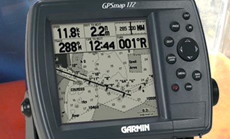
There are two types of GPS receiver typically bought by boaters. At a simple level basic GPS units have small screens, cost £100 – 200,
and only show the lat and long plus various other items of information. The next level up (and an increasingly common option that is coming down in price almost daily) are chartplotters. A chartplotter is
a ‘souped up’ GPS that contains electronic versions of the paper charts we use and overlays the position of the craft on those charts. One of the advantages of chartplotters is that whereas
with basic GPS units you need you to key in manually the lat & longs of waypoints a chartplotter allows you to position the cursor on the chart and press a button to create the waypoint. This can be
quicker, simpler and less prone to input error. One of the downsides of a chartplotter though is that it can be difficult to get the ‘overview’ that
a paper chart gives. Zoom in and you focus on a small area and cannot see much beyond the immediate vicinity, zoom out and the detail of the chart is less visible – have a chart AND a chartplotter.
Key points to remember about GPS:
Ensure the GPS receiver is set to the correct datum – WGS 84 (this is then the same as newer charts meaning satellite derived
positions can be plotted directly onto a chart.) – if you don’t there is an error between the chart and the GPS.
The compass will only work when the set is moving – unless the set has an inbuilt fluxgate compass.
Do not rely exclusively on GPS as its accuracy and existence relies on the US Government. They may need to switch it off or create a random accuracy error (called ‘Selective Availability’)
from time to time.
Using your GPS to navigate between two points:
Initially choose and input your waypoints
You can then link the waypoints together to form a route. Care must be taken not to miss out any waypoints from your route.
If you have any enquiries relating to the GPS for your vessel, please call us on (087) 280 7028 or e-mail us at info@truelightmarine.ie.
|
|
Relying on Technology
Don't rely solely on technology.
One of the advantages that technology gave to this world is that it made things to be done efficiently and without any delay. With new and exciting technology being developed all the time, standards
of training can sometimes be overlooked
It is just important to always bear in mind that if the technology fails, do you think you can do the job for yourself.
You might forget what you have learned if you depend so much on high end technologies right now, and at the very time you need it the most, you may find safety training will get you home safe when technology lets you down
Truelight Marine offer training and service programs, available to prepare you for any situation that you can find yourself in.
more about safety training >>
|
|